Compass Point
CONTACT
Credit Sales Coordinator, North Carolina

Compass Point | During construction

Compass Point | Completed construction

Compass Point | Working downstream
PROJECT SNAPSHOT
Project Type
Mitigation BankLocation
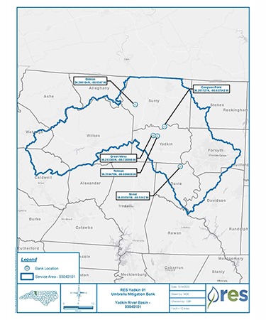
North Carolina | Yadkin CountyService Area
Yadkin 01Project Size
- Streams: 5,304 LF
Solution
Wetland and Stream MitigationCredit Types
- Stream
Ask About Credits
The Compass Point Mitigation site is located in Yadkin County, approximately 4.5 miles northeast of Boonville. The project presents 5,304 linear feet (LF) of stream restoration and enhancement generating cool stream mitigation Units (SMU) along three unnamed tributaries that drain directly to the Yadkin River within Cataloging Unit 03040101, 12-digit United States Geological Survey (USGS) HUC 030401011001, and North Carolina Department of Water Resources (NCDWR) sub-basin 03-07-02. The current State classification for the Yadkin River at this location is Class C (NCDWQ 2011).
The project’s total easement area is approximately 165 acres within the overall drainage area of 271 acres. Water quality stressors currently affecting the Project include livestock production, agricultural production, and lack of riparian buffer. Grazing livestock have historically had access to most stream reaches within the Project. The lack of riparian buffer vegetation, deep-rooted vegetation, and unstable channel characteristics have contributed to the degradation of stream banks throughout the project area.
The project provides numerous ecological and water quality benefits within the Yadkin River Basin by applying an ecosystem restoration approach. The restoration approach at the reach scale of this project will have the greatest effect on the hydraulic and geomorphology function of the system but will benefit the upper-level functions (physiochemical and biology) over time, and in combination with other projects within the watershed. Buffer improvements filter runoff from agricultural fields, thereby reducing nutrient and sediment loads to the channel. Livestock exclusion fence was installed along the easement boundary. The widening and restoration of the riparian areas will also provide wildlife corridors throughout the Project area. Benefits to be accrued from these activities include improved water quality and terrestrial and aquatic habitat. Stream construction was completed in May 2020.