Scout Mitigation Project
CONTACT
Credit Sales Coordinator, North Carolina


PROJECT SNAPSHOT
Project Type
Mitigation BankLocation
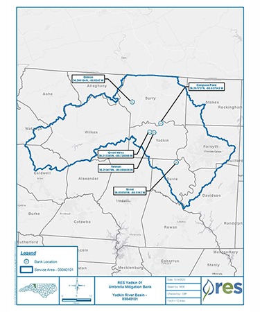
North Carolina | Davie CountyService Area
Yadkin 01 River Basin | HUC 03040101Project Size
- Streams: 3,144 LF
Solution
Wetland and Stream MitigationCredit Types
- Stream
Ask About Credits
The Scout Mitigation project is located within an agricultural watershed in Davie County, approximately eight miles west of Clemmons and five miles northwest of Bermuda Run within Yadkin River HUC 03040101, in TLW 03040101160010. The project area is comprised of a single easement located along Hauser Creek and two unnamed tributaries. The project is located between two sections of the 27-acre DMS Mockingbird site and upstream of the closed-out DMS UT to Hauser Creek project. The DMS Catbird site is in an adjacent catchment to the east. Livestock production, agricultural practices, and a lack of riparian buffer have historically impacted the streams proposed for restoration.
Goals for the project include increasing hydrologic function and restoration to ecological function within the existing stream and riparian corridor, as well as protecting these features in perpetuity. These will be accomplished by returning the existing streams to stable conditions by constructing an E/C type stream with appropriate dimensions and patterns, reconnecting Hauser Creek to the floodplain, and backfilling the abandoned channel. In-stream structures will be installed for vertical stability and to improve habitat, where necessary. Buffer improvements will filter runoff from the surrounding pasture lands. The project presents 3,144 LF of stream restoration and enhancement, generating 2,918 Warm SMUs. Construction was completed in May 2020.